Project Results:
ISGEAG
Improving sustainable groundwater exploration
About
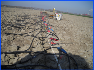
This project was a kind of action research with the aim to improve geophysical practices for groundwater prospecting. When the most geophysical survey methods are applied, results are better interpreted, consistent and well-founded, it will lead to better borehole drilling results and a strengthened understanding of the geography of regional aquifers. Different traditional geophysical groundwater prospecting technologies were used and compared with the most recent ones. Three geological settings were selected to test different methodologies: Basement (Kajiado), Coastal sedimentary (Kwale) and Volcanic (originally Kakuma, changed to Naivasha). Selected areas suffer from serious water stress, mainly caused by poor groundwater quality.
Key results
-
3 studies in which different geophysical methods are compared: they provided good insights in the potential of the different geophysical methodologies, especially when some of them are combined.
-
The studies show that surveys can be done much better to reach higher efficiencies in borehole drilling and get better insights in the geography of aquifers for safe exploitation.
-
3 practical trainings, in which many experts were trained: this helped the research made widely known among the stakeholders.
-
Valuable input for the Kajiado Sponge town project.
Tips for the future
-
Main challenge is getting the Water Resources Authorities (WRAs) involved, the essential institutions for reform of water resource exploration. As soon as WRA will change the rules, the improvement of practice will spread faster.
Project partners
Acacia Water (and Wiertsema & Partners), SamSam Water, KenGen, AMREF Health Africa in Kenya
Period
September 2016 - March 2019
Location
Mombasa, KenyaKakuma, Kenya
Kajiado, Kenya
Last project updates
Background
In Kenya, geophysics are prescribed for underground surveying and borehole siting. Experience and geophysical reports show that there is a general lack of knowledge on the applicability of the different methods and results are misinterpreted. As a consequence, drilling success rates are low, overexploitation is problematic (particularly close to urban and urbanising areas), and new groundwater reservoirs remain unexplored.
Site selection for boreholes is currently based on methods that have a very low resolution beyond depths of 50 to 70 meters. As such, very limited information is available to characterize the groundwater reservoirs and assess the potential for water abstraction.
Drinking water supply in urban environments is being undermined by the posed challenges. As groundwater levels are dropping, more and more wells are running dry or becoming saline. Water scarcity in and around urban areas is increasingly a problem. In Kajiado Town, for example, a jerrycan nowadays go for up to 60 Kenyan Shillings (KShs), which cannot be afforded by the urban poor. Safe drinking water supply and good hygiene conditions are threatened by these high water prices. Women, children and elder are most affected. Women and children have to cover ever large distances to fetch water. In addition, poor safe water availability undermines good nutrition, health and economic productivity. The ISGEAG-project aims to improve borehole siting and design, stress the importance of proper groundwater management, and hence improve the success rate of borehole drilling and hence access to safe water.
It should be clear that geophysical exploration in city centre’s itself is not possible because of the background noise and shielding effects due to electrical wiring, iron pipes, iron forced concrete, pavement etc. The exploration in these kind of environments is always executed outside the city’s (centre) because of this noise but also because of the fact that these aquifers need to be extensive (high yields) and protected against pollution. Superficial, small-scale aquifers do not have enough capacity (all year around) and are sensitive for pollution.
Project Plan
The project combines research and capacity building. Research will focus on which geophysical methods to use where, how best to analyze the measurements, the formulation of analysis guidelines and the development reporting standards. This will be done through the application of traditional, existing and new geophysical methods in 3 reasonably well researched areas in Kenya (Kakuma, Kajiado and Mombasa). Kakuma will be the first research location to be visited, most likely at the end of February, 2017. The other locations will follow later on in 2017 and early 2018.
The capacity building trajectory aims to train and equip local teams and stakeholders with a strengthened knowledge base on geophysics, improved integrated assessment skills, and knowledge of the use of the new guidelines and reporting standards.
Target group
Increased success rate of borehole drilling and, thus, water availability will alleviate the burden of fetching water and reduces the occurrence of water-borne diseases. This particularly benefits the urban population, the poorest, women and children.
Knowledge dissemination and widespread capacity building are also central to the project. The on-the-job capacity building trajectory aims to train and equip local teams and stakeholders with a strengthened knowledge base on geophysics, improved integrated assessment skills, and knowledge of the use of the new guidelines and reporting standards. The project targets Kenyan hydrogeologists, geophysicists, surveyors, supervisors, students, water managers and WASH-experts from NGOs. The project will work in close collaboration with local NGOs, authorities and other organizations involved in water management, such as: KenGen, AMREF Health Africa, WASH Alliance Kenya, the University of Nairobi, Water Resources Management Authority (WRMA), Earth Water Consultants Ltd., Kenya Water Institute (KEWI) and Kenyan Water and Sewerage Companies. Female students will be specifically addressed to join the training as they are known to have complementary skills to those of men and, on the other hand, to ease their access to the job market after their studies. In general, the trajectory focuses on the development of analytical skills.
Sustainability
Sustainability will be achieved through disseminated and increased knowledge capacity of Kenyan professionals active in groundwater exploration. This will result in better interpreted, consistent and well-founded assessment of geophysical survey results, leading to better drilling results and a more sustainable abstraction of groundwater. Hence, the burden of fetching water is alleviated and occurrence of water-related diseases reduced. This particularly benefits the urban population, the poorest, women and children.
Overview of Goals
The project foresees the following main outcomes:
1. Improved practices in the use, interpretation and application of (traditional) geophysical surveys, so that it is truly distinctive in finding the best location for new boreholes
2. Introduction, validation, and integration of ‘new’ geophysical methods4 for groundwater exploration
3. Introduction of “minimal” reporting standards for consultants involved in geophysics and groundwater exploration.
4. Strengthened understanding regional (fractured) aquifers, their recharge processes and their status of (over)exploitation.
5. Improved awareness and knowledge about basic monitoring and mapping programs useful to support groundwater exploration.
6. Improved knowledge-sharing between the local Kenyan partners on geophysics, groundwater exploration and borehole drilling. In future, this should lead to a Kenyan-based expert team that can further develop the knowledge base and support other parties
