Project Results:
The project ‘Urban flood risk assessment in African cities – case study Accra’ had the objective to analyse the flood risk in Accra and to develop a general methodology for urban flood risk assessment in African cities. The students carried out a field survey in Accra, taking measurements of the drainage system and collecting information on waste management and other factors influencing the flood risk. Based on the measurements a hydrological model was built to be able to answer the research questions: 1) what are the causes of floods in Accra; and (2) what are useful elements in developing a methodology for flood assessment in African cities, using an innovative and integrated approach.
Key results
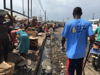
- Several challenges were identified that hamper good drainage and the predictability of flooding, such as the accumulation of waste
- Problem areas were quickly identified with stakeholders
- Crowd sourced risk mapping through social media were very efficient
- A flood assessment method was developed and documented
- The findings were used for building a hydrological model, used in another VIA Water project (Flash Flood App Accra)
Tips for the future
- Student reports need a quick formalization and follow-up to avoid loss of information
Potential for growth
Project resulted in a methodology, for which a guideline was produced. Please consult the project owners as the original web-link is not working any more.
Project partners
HKV Lijn in Water (Lead Party) TU-Delft, KNUST, UDS, Witteveen+Bos,
Period
May - August 2016
Last project updates
Background
The background for this research lies in the societal challenges that many African cities are facing under pressure of climate change; urban floods events. In the last few years, severe floods hit the capital city of Ghana, Accra. On June 3rd 2015, heavy rains created flooding that impacted many parts of the Greater Accra Region. Over 200 people lost their lives and many more were displaced and lost their property and livelihoods. In addition to this, are the costs of disrupted traffic and economic activities. Besides the impact of the generated flood wave, the contaminated water put the health of communities at risk.
Accra serves as an example for other African cities with similar development patterns. The rapid urban expansion (in part due to drought induced migration) has transformed the surface of the city into a nearly impervious area. There is hardly any infiltration of rainwater and the retention capacity for flood water is limited. This leads to larger run-off flows that need to drain out of the neighborhoods. Currently, Accra’s urban drainage system is not capable of coping with the generated flows of extreme rainfall events. This could be due to the layout and dimensioning of the network. Also, the accumulation of solid waste in the drains could have a negative impact on water safety and quality. In some parts the run-off might even be blocked by high sea water levels.
In order to reduce disaster risk and losses in lives, livelihoods and health globally, priorities have been set-up under the Sendai Framework for Disaster Risk Reduction 2015-2030. The first priority for action is ‘understanding disaster risk’ and explains how “disaster risk management needs to be based on an understanding of disaster risk in all its dimensions of vulnerability, capacity, exposure of persons and assets, hazard characteristics and the environment”. In an environment with little available field data of the urban drainage system, such as Accra and other African cities, it remains a challenge to evaluate the flood risk of the city.
The study of the current solid waste handling is essential to come up with solutions for the flooding problems. Accra’s official waste disposal sites are small and overloaded, encouraging illegal disposal in drains or the ocean. The effect of waste disposal in the drains and increase of urban flood risk seems apparent. However, the relation between solid waste management and discharge capacity of the urban drainage network has not been quantified in a scientific framework. A systematical assessment of the accumulation of litter in the drains and the origin of the waste is needed in order to get an insight into the effect of solid waste on flood risk.
Project Plan
To reach the objectives and improve risk management in Accra the following approach is used:
• Remote sensing data & Smart field surveys. Building a drainage model in developing countries is often complicated because of the lack of field data. We build a hydrodynamic model using remote sensing data optimized by data gathered during fieldwork with a team of Ghanaian and Dutch students, supervised by experts. The students will take measurements throughout the pilot area on the dimensions and capacities of the drains making use of the Akvo FLOW services.
• Waste management & Urban drainage. We believe that investigating and quantifying the impact of solid waste on the discharge capacity of the urban drainage system is essential to understand and reduce flood risk in the cities of the global south. In order to get an insight into the effect of solid waste on flood risk, the students will systematically study the accumulation of litter in the drains and assess the origin of the waste. Besides mapping the existing challenges, the feasibility of waste recycling business models will be investigated.
• Experimenting with Social Media to gather information on the status of the drainage network. Geo-referenced pictures of drainage solutions at street level taken by inhabitants are collected and analyzed to create a map of the drainage system.
• Collaboration with mapping specialists at Open Street Map initiative Ghana (who have recently mapped the district of Kwame Nkrumah Circle after the flooding disaster in June 2015 (http://www.codeforghana.org/2015/06/30/openstreet.html) will allow for integration of data and scaling up of our fieldwork activities. Humanitarian Open Street Mapping initiatives to support disaster prevention and response to areas that were previously off the map, like the project to map the urban drainage system in Dar es Salaam, Tanzania, form the inspiration.
• Disaster Risk Reduction. The current drainage capacity is assessed and simulated using the rainfall scenarios of historic flood events and flood-prone, vulnerable areas delineated. This enables the set-up of DRR approach in which the team will identify measures that will reduce the flood risk and enable safe and healthy city life in Accra.
Next to technical flood risk mapping, an institutional and financial analysis will address ways to protect Accra against floods from a governance standpoint. To make future implementation sustainable, a close cooperation with local stakeholders as mentioned above (The Clients) through the set-up activities such as workshops, surveys, interviews and a waste removal missions are planned.
• Accra is used as a showcase in the development of a generic Methodology for urban flood risk assessment that can be applied in African cities facing similar issues. All data and findings are shared openly. Outcomes of the project will be shared with other VIA water projects related to flooding.
Target group
This project brings together relevant stakeholders in urban drainage in Accra from the City Council AMA & various governmental departments (HSD, URD, WMD), NADMO, Ministries (MLGRD, MWRWH), universities, consultants, institutions (IWMI, WRI), World Bank to inhabitants in order to find solutions for the regular flooding problems in Accra. This project helps them to better understand the flooding problems and identify solutions to secure the people of Accra.
Sustainability
Results from this assessment will serve long-term sustainable goals to improve the city’s urban drainage infrastructure, benefiting and securing Accra’s inhabitants. This pilot study leads to increased knowledge of participating partners which can be beneficial for future projects.
Furthermore, the data gathered through this project will be shared with an existing VIA Water project related to flooding in Accra, the Flash Flood forecasting app launched by RHDHV, 3Di, infoplaza and NADMO. More detailed information on the micro drainage and dimensions of the primary drainage system can help improve the model that backs the forecasting application.
Moreover, this project is an opportunity to develop a methodology for disaster risk reduction in other African cities. By using Accra as a showcase, we develop a methodology for urban flood risk assessment which gives a quick, yet detailed insight into the risks and bottlenecks of the drainage system combining remote sensing and field data. This method can be used by local students in Ghana to continue to map flood risk in their cities.
The universities and consultants in the project will bring their knowledge together. The fieldwork enables Dutch and Ghanaian students to learn about water management in the field and prepare them as future water engineers. Therefore, the project includes a capacity building component. The activities organized by the project team initiate involvement and raise awareness about the flooding problems in Accra among all stakeholders.
Overview of Goals
1. ‘To analyze the flood risk and assess the causes of urban flooding in a pilot area, using an innovate and integrated approach’
2. ‘To develop a methodology for urban flood risk assessment that can be applied in other African cities facing similar issues’
Results and indicators
- Risk assessment report on pilot area
- Organized database of fieldwork data
- Hydrodynamic model of pilot study area
- Methodology for urban flood risk assessment report